![[bc]](http://images.squarespace-cdn.com/content/v1/5248ebd5e4b0240948a6ceff/1412268209242-TTW0GOFNZPDW9PV7QFXD/bcW_square+big.jpg?format=1000w)
By Emily Axtman
This is a post in a series on the La Hacienda Casitas and the Lower Rio Grande Valley.

Harlingen, TX is located in the Lower Rio Grande Valley, which is comprised of 4 counties: Starr, Hidalgo, Willacy and Cameron. Both Harlingen and Brownsville are in Cameron County. Harlingen, 30 miles west of the Gulf of Mexico and 15 miles north of the US / Mexico border, enjoys warm (or hot in August) gulf breezes and plenty of tropical vegetation — my favorite being the Sabal palm tree.

Harlingen's roots go back to the early 1900s when Lon C. Hill, a Valley pioneer and developer, convinced his buddy B.F. Yoakum of the Missouri Pacific Railroad system to build a railroad from Corpus Christi to Brownsville with a stop at a junction just 25 miles north of Brownsville. Hill had built his home here not long before. In the early days this crossroad was known as "Six-Shooter Junction", referencing the Texas Rangers and Border Patrolmen who lived there. The town was later named Harlingen in tribute to Harlingen in the Netherlands, which has a similar canal system.

Harlingen, Friesland (a little different than how the canals look in the Valley)
By 1911 the town’s population numbered 1,126 people. Local economy was almost all agriculture, mainly producing cotton and vegetables. In the following decades, Harlingen grew into a distribution, shipping, and industrial center, conducive to its location as a crossroads.
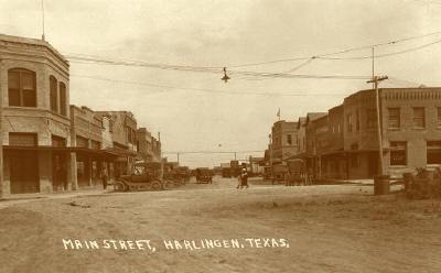
Harlingen in 1918. Photograph: www.texassoldphotos.com
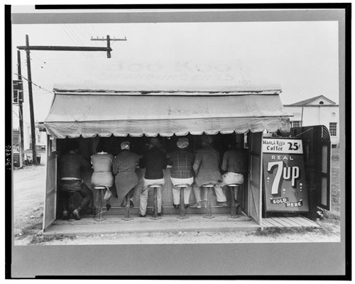
Hamburger stand in 1939. Photograph: Russell Lee.

Highway between Harlingen and San Benito in 1940. Photographer: unknown.
At about the beginning of WWII, Harlingen was chosen by the War Department in Washington, D.C. in 1941 as a new air-base under the U.S. Army Air Corps. It was projected to support 114 Air Corps officers, 37 arms and services officers, 1660 Air Corps enlisted men and 495 arms and services enlisted men, as well as 600 students. With the military presence, Harlingen's population rose to 23,000 by 1950.

Air Force Base. Date unknown. Photograph: City of Harlingen. The base closed in 1962.
By the 1980s Harlingen's main economy was based on citrus fruit production with tourism surprisingly second in line, with grain and cotton following. Economic development now centers around wholesale and retail trade, manufacturing and service industries, as well as large-scale construction. Today Harlingen's population is at about 65,000.

Downtown Harlingen in 1975. Photograph: Frank Whaley Postcards.
I've driven to Harlingen twice now. It did not look quite like the retro card above. Of course it has undergone four decades of change since this photograph was taken.
If you drive out of downtown, taking HW 83 west (formerly the Missouri Pacific rail line), you'll pass a huge highway interchange. Pass some mobile-home parks on your left and you'll hit Wild Bill's (you can guess what that is. Ladies' Night is Thursdays). Take a left on Paloma Lane, a quiet rural 2-way road, and to the left you'll see the La Hacienda Casitas site.
It will appear as though something used to be there, which is true. It is the previous site of 56-unit housing development built in the 1950s that had been converted from a motor court. The houses were in disrepair and removed in preparation for the La Hacienda Casitas. The landscape is now rugged, with wild grass and beautiful trees, which we have worked hard to preserve as many as possible.

Previous site condition.
After visiting the site three times and digging deeper into the history of this project, I have a few questions:
What were the circumstances that led CDCB to this site in Harlingen?
And why did CDCB choose to do their first multi-family housing project now and in Harlingen?
How did bcWORKSHOP become partnered with CDCB?